AEMET increases yellow weather warnings for wind, rain, and rough seas


The State Meteorological Agency (AEMET) has updated and increased the yellow weather warnings for the Canary Islands, which now cover three main hazards: strong winds, heavy rain, and rough seas.
In response, the Canary Islands government has declared an official alert for coastal conditions in several areas, with pre-alerts issued for rain and wind.
Island-by-Island Breakdown of Warnings
TENERIFE:
Tenerife faces three yellow weather warnings as follows:
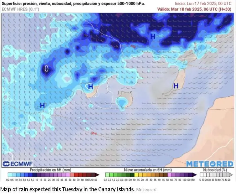
· Rain: Expected in the north of the island, with rainfall accumulation of up to 15mm per hour, particularly in mid-altitude areas. The warning is active from 3:00am to 9:00am today, Tuesday.
· Wind: Strong gusts of up to 70 km/h are forecast, especially in the metropolitan area and mid-altitude regions such as Tacoronte, San Cristóbal de La Laguna, and El Rosario. The warning is in place from 3:00am to 9:00am on Tuesday.
· Rough seas: Affecting all coasts of the island, particularly the north and northwest, with combined waves of 4 to 5 metres and periods of around 14 seconds. This warning is active from 7:00am on Tuesday until 12:00pm on Wednesday.
GRAN CANARIA:
· Rough seas: Affecting the northern coast with waves of 4 to 5 metres and periods of around 14 seconds. The warning is in effect from 12:00pm on Tuesday until 12:00pm on Wednesday.
FUERTEVENTURA:
· Rough seas: Waves of 4 to 5 metres are expected along the entire coastline. The warning runs from 1:00pm on Tuesday until 3:00pm on Wednesday.
LANZAROTE:
· Rough seas: The island faces waves of 4 to 5 metres along all coasts. The warning is in effect from 1:00pm on Tuesday until 3:00pm on Wednesday.
LA PALMA:
Three warnings have been issued:
· Rain: Expected on the island’s summits and western regions, with up to 15mm of rainfall per hour, primarily on the western and northern slopes. The warning runs from 9:00pm last night, Monday, until 6:00am on Tuesday.
· Wind: Gusts up to 70 km/h in the eastern and northern regions, particularly affecting exposed highlands and mid-altitude areas. This warning is active from 9:00pm last night (Monday) until 7:00am on Tuesday.
· Rough seas: Affecting the eastern and western coasts, with waves reaching 4 to 5 metres and periods of 14 seconds. The warning is in effect from 4:00am on Tuesday until 12:00pm on Wednesday.
EL HIERRO:
Three yellow warnings apply:
· Rain: Forecast across the entire island, with 15mm per hour expected, particularly in mid-altitude areas. The warning is active from 3:00am to 9:00am on Tuesday.
· Wind: Strong gusts of up to 70 km/h are predicted, particularly in the northeast and at high altitudes. This warning is in effect from midnight until 7:00am on Tuesday.
· Rough seas: Affecting all coastal areas, with waves of 4 to 5 metres and a period of 14 seconds. The warning is in place from 5:00am on Tuesday until 2:00pm on Wednesday.
LA GOMERA:
· Rough seas: A warning is in effect for all coastal areas, with waves of 4 to 5 metres and periods of 14 seconds. It is active from 8:00am on Tuesday until 12:00pm on Wednesday.
Authorities Advise Caution
The government has urged residents and visitors to exercise caution, particularly in coastal areas where rough seas pose significant risks.
Travellers should check for potential transport disruptions, while outdoor activities in affected areas are discouraged during the warning periods.
With the weather conditions subject to change, updates from AEMET and emergency services should be monitored closely.
Share:


