Seismic activity and rise of magma has mis-shaped the surface of La Palma
- 15-09-2021
- Tenerife
- Canarian Weekly
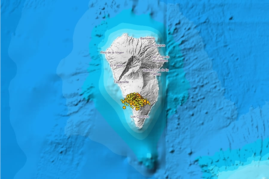
An earthquake of 3.2 magnitude was recorded at 10.25 am this morning (Wednesday) at a depth of just 7 kilometres and felt by the residents of the municipality of El Paso, according to the National Geographic Institute (IGN). This is the highest magnitude seismic movement of the more than 90 that have taken place in La Palma today, after one of 3.1 magnitude was measured at 6.15am.
Since the 'seismic swarm' began on Saturday, over 700 earthquakes have been officially recorded, the activity has been shifting west and the average depth of earthquakes has decreased dramatically. The latest movements on the island have been under El Paso, Tazacorte and Fuencaliente, at depths between 6 and 14 kilometres, whereas previously they were at 30 kilometres.
However, it is still unknown whether this swarm of seismic activity, which has forced the yellow alert in the towns of Los Llanos de Aridane, Fuencaliente, El Paso and Mazo, will lead to an eruption or not.
Itahiza Domínguez, an IGN seismologist explains that "There are several possible scenarios. This could come to nothing, end today, tomorrow or a week from now, or end in an eruption. It is not impossible, but what we have right now is a seismic swarm at a depth of 8 or 10 kilometres, accompanied by a slight deformation of the ground of 1.5 centimetres".
This deformation of the ground is due to a magmatic intrusion in the lower area of the island's crust. Before, the magma was accumulating in the mantle, but now it is pushing up. However the intensity of the tremors would need to increase to over 5 on the Richter scale and the deformation be approximately between 10 and 15 centimetres before you could say for certain that there would be fractures in the surface to release gases or magma.
However, Domínguez says that “This is the ninth swarm that has occurred in Cumbre Vieja since 2017, although the previous ones were registered at greater depth. But in view of the data, we cannot rule out an eruption in a short time, although there is also no guarantee that it will happen.”
VOLCANIC ALERT LEVELS:
GREEN: Pre-alert situation. This is the level the islands are normally in as there is always light seismic activity communicated to the population, aimed at maintaining "a state of care and vigilance."
YELLOW: This alert, which La Palma is currently under, is activated when the Scientific Committee deems that the level of activity is intense enough to start alerting the population of a potential emergency situation. Under this alert level, the coordination of emergency teams is also activated so that if the evacuation of a town is necessary, all relevant plans are in place.
ORANGE: A very short-term prediction of an eruption. In this situation, the preventive evacuation of the population is carried out with all the operational services ready, as physical volcanic activity is imminent.
RED: The red traffic light situation can only be declared when the volcanic eruption is confirmed and it poses a risk to the population or fundamental infrastructures (buildings, roads etc). At this level, a state of emergency is declared.
Other articles that may interest you...
Trending
Most Read Articles
Featured Videos
A Vision of Elvis Tenerife Promo
- 10-05-2025
TEAs 2025 Highlights
- 17-11-2025


