New storm set to bring heavy rain to the Canary Islands all this week


A new Atlantic weather system is expected to bring several days of unsettled conditions across the Canary Islands this week, with forecasts pointing to widespread rain, strong winds and even snowfall on the highest peaks.
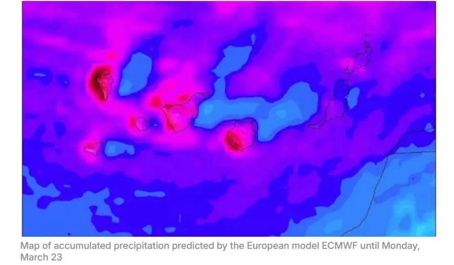
According to projections from the European weather model (ECMWF), the storm will begin affecting the archipelago from tomorrow afternoon (Tuesday) and could continue through to the weekend.
Rain expected from Tuesday
Meteorologists indicate that the approaching low-pressure system is moving south from the North Atlantic and will position itself to the west of Madeira before gradually shifting southeast towards the Canary Islands.
Although forecasts still carry some uncertainty several days ahead, current models suggest that rainfall will return on Tuesday afternoon. The first showers are expected in Tenerife and the western islands, before gradually spreading eastwards across the rest of the archipelago during the following days.
By Wednesday, rain is forecast to become widespread across the islands, with the heaviest accumulations expected in La Palma and Gran Canaria. Winds are predicted to blow from the west in Tenerife and the western islands, and from the south in Gran Canaria and the eastern islands.
Forecasters say that periods of heavier rainfall could develop along Tenerife’s east coast later in the day.
Possible snowfall on Tenerife
Unsettled weather is likely to continue on Thursday across most of the Canary Islands. While Lanzarote and Fuerteventura may initially see lighter rainfall, heavier showers are expected elsewhere, particularly in La Palma and Tenerife.
Snow is also possible on Tenerife’s highest peaks from around midday. As the afternoon progresses, rainfall totals could increase significantly across Tenerife, La Palma and Gran Canaria, accompanied by south-westerly winds and snowfall continuing at high altitude on Tenerife.
Very wet weekend ahead
Conditions on Friday are expected to remain similar, with heavy rainfall continuing in the more mountainous islands of Tenerife, Gran Canaria, and La Palma. By the afternoon, showers are also likely to extend to Lanzarote and Fuerteventura. Snow may persist on Tenerife’s summit areas.
On Saturday, winds are forecast to shift to the west, bringing thicker cloud and further rainfall across much of the archipelago. The wettest areas could include the south-west of Tenerife and Gran Canaria, as well as western parts of La Palma, La Gomera and El Hierro.
The unsettled pattern is currently expected to continue into Sunday, with rain affecting all islands. Westerly to north-westerly winds are forecast in the western islands, while the eastern islands may experience south-westerly winds.
As the end of the week approaches, forecasts could still change. However, if current predictions hold, the State Meteorological Agency (AEMET) may issue official weather warnings, and the Canary Islands Government could activate precautionary alerts.
Share: